|
Swedish
Space Corporation's EBBA Image Processing System
|
|||||||||||||||
|
EBBA was a series of inexpensive image processing systems developed by Swedish Space Corporation in the period 1980 to 1988. (EBBA was an acronym for Inexpensive Image Processing Device in Swedish.) I was involved in its development in a managerial role, but I also contributed to its software. EBBA is an interesting subject, not only to those who were directly involved, but also as part of the history of image processing in Sweden. In addition, it may offer some insights into the process of bringing technological innovation to the market. EBBA had its roots in an "intelligent" image display memory developed by SSC for the Swedish Coast Guard. Hard as it may be to believe today, in the late 1970s there was no easy way to display raster images on a computer. As late as 1976, I visited a major European research institution and discovered that their preferred method of generating thematic satellite images was to print out text symbols on paper, and then color homogeneous areas (correspondig to water, forest etc.) by hand!
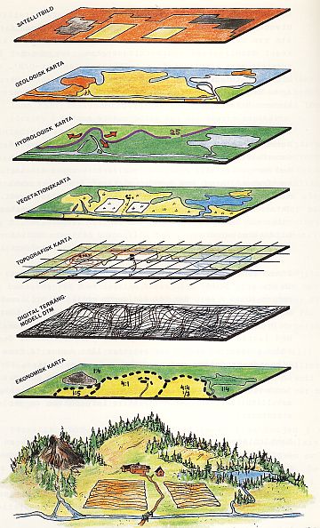
I also remember how thrilled I was, when, at a visit at the Swedish Defense Research Establishment, a terminal was demonstrated, where an image was slowly being built up on the screen line by line. This may seem unreal today, when any PC can process and display an image from disk (or even the Internet) instantaneously. The image memory that we had developed for the Coast Guard was used to display data from an airborne infrared scanner in real time in the aircraft. We had looked for alternatives but had found nothing suitable to be available on the market. In 1979 we took delivery of an Image Analysis System (IAS) from MDA in Vancouver hosted on a state-of-the-art Interdata 32-bit minicomputer. (See separate account.) Its powerful image manipulation possibilities (the "SPIEL" program) inspired us to think seriously about what might be achieved using a microprocessor for processing and displaying satellite images. Our point man in testing and accepting the IAS, Sonny Lundin, wrote a tentative specification for a simple EBBA in August 1979. SSC had a major stake in the success of satellite remote sensing. We had recently set up a Landsat receiving station in Kiruna and had acquired the IAS without government support. On our advice, Sweden had invested in the SPOT satellite system still under development, and we were about to launch a daughter company of SSC to commercialize SPOT data products. Now we needed to show that satellite data could be useful in Swedish applications. This meant showing that satellite data could be integrated with other types of land information, such as aerial photography, maps and statistical data. We needed to demonstrate the potential to prospective users, and to convince them to integrate the new source of data in their information systems. We clearly had a long way to go, but we were encouraged by our initial results, working on the IAS with forestry and hydrology specialists. We realized that we needed to bring image processing "to the masses". For any serious applications to materialize, the users needed to develop their own expertise and control their own information processing tools. They could not be expected to rely on SSC for their operational needs. This was the background for EBBA. We wanted to quickly develop an inexpensive tool for visualizing and exploiting satellite data and other forms of raster data. (Any type of scanned data, including scanned X-ray images in medical applications, could benefit.) This "philanthropic" approach was in contrast to a profit-maximizing scheme (although we did not exclude taking a more commercial approach at some future time). It also made it possible to solicit government financing for the development effort (with a fixed royalty to be paid in case we turned the project into a commercial success). Our primary targets were university institutions and developers of methodology in public and private organizations.
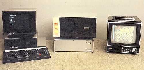
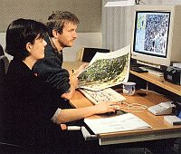
An in-house prototype of EBBA was developed in 1980. It had 3 layers of 256*256 pixel 8-bit mage data and 4 layers of 256*256 pixel 1-bit data (used for graphic overlays). Data were read from a diskette or from a tape recorder. Basic image processing functions were available, such as interactive contrast enhancement, pseudo coloring, readout of position and intesity values of each pixel, defining an area using the graphic overlays and performing statistical analysis in the defined area, addition and subtraction of grey values, zoom function etc. The software was written in assembler language and partly in Basic. More advanced processing, such as thematic classification and geometrical precision corrections, were not supported. All EBBA functions were commanded from a Swedish microcomputer (Metric 85). A total of 15 EBBA-I boxes were manufactured. We considered this quite encouraging, considering the system's limitations and the lack of maturity among Swedish users. EBBA-II was developed in 1983-84. Its image memory had now been upgraded to 3 layers of 512*512 pixels and 8 graphic overlays of the same size. A number of peripherals were included as options: a video camera, a digitizer (for capturing map coordinates), a color printer, and a Winchester disk drive. The newly introduced IBM PC was chosen as the standard host computer. (On the strength of an article I had read in Business Week, I had concluded that IBM was likely to define the standard for future personal computers. Its success depended on the popularity of the VisiCalc spreadsheet program, used by "bean counters" everywhere in corporate America.) We also developed a version for the VAX minicomputer. The basic functions were written in assembler language and optimized for speed. They were "burned" into programmable memory ("firmware") and called from the host, which could also combine them and perform more complex operations.
Those were exhilarating times. We felt that we were in the frontline of technical development and were building wonderful things. Our engineers put their souls into their work. Invariably, when I visited the office on a Saturday to compose a memorandum or "play" with the IAS, I would find the project manager Bengt Holmqvist and his colleagues Gudmund Johansson and Hans Ringstrand there, working in their free time. Pride and passion were their motivation. In parallel, a rudimentary production and sales organization was set up. Top management directed that EBBA should be produced at our Esrange facility in northern Lapland, some 800 miles north of Stockholm, where some surplus capacity was available. Our sales efforts included a presentation at a large symposium in Paris in 1984. One of our less expected customers was a small handicraft company, which wanted to use EBBA to design new textiles patterns. There were some glitches. Production at Esrange was hampered by sickness and shifting priorities, which in turn led to quality problems. The physical distance did not help. Our development team was forced to spend several weeks identifying and correcting production mistakes. An unrelated issue was that the original design turned out not to be sufficiently robust. Electric pulses would occasionally arrive in the wrong order. Again, it required an extra effort to identify and correct the problem. The whole development was done on a shoestring budget. Through 1984 approx. SEK 1 million was spent, half of which was financed by the government. (1 MSEK in 1984 equals approx. 2 MSEK in 2010, which corresponds to approx. € 200 k or $ 300 k in current terms.)
In 1984, all remote sensing activities within SSC were organized into a separate division headed by Håkan Kihlberg. Håkan came from IBM, where he had been a sales manager. He brought discipline and methodology to our work, with a clearer division of responsibilities between the development, production and sales groups. Despite the difference in our backgrounds, I found it easy to work with him. He was a tough, inquisitive "no-nonsense" leader, but being computer-literate he also fully appreciated our technical achievements and understood their commercial potential. His arrival shortened the time needed to get decisions. Håkan quickly approved various upgrades to EBBA and gave the green light to start development of the third EBBA generation. He also established a partnership with a Canadian company, PCI. (They had a software package called PACE. When their representative saw our slogan SPACE IS OUR PLACE, he quickly scratched out a few letters so it read PACE IS OUR ACE.) In 1985 Håkan started a cooperation with Geobased in North Carolina, a company specializing in geographic information systems. EBBA-II was quite successful as an instrument for the promotion
of decentralized image processing and the development of applications
of satellite data. Some 30 systems were sold, some of them to foreign
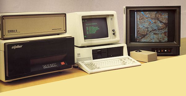
countries. Our third generation EBBA was named EBBA-GIS to emphasize our ambition to turn it into a complete geographic information system based on a desktop computer. The hardware was expanded to three 8-bit image planes of 1024*1024 pixels (with 512*512 viewable on the screen) and eight 1-bit graphic planes of 1024*1024 pixels. The software offered on the host computer was greatly expanded. It included raster-to-vector and vector-to-raster conversion and geometric precision corrections. (See system description.) We introduced it at an international symposium in Beijing in 1986. We felt that we had at least a one-year lead over our competitors at the time. Their main problem in handling image data was that they were forced to handle all processing in general-purpose computers, which sometimes seemed glacially slow, while our EBBA processor was lightning fast. Again we received a modest contribution from the Government for the development of EBBA-GIS. This time the cheque was endorsed by the Minister of Industry!
Håkan's departure effectively doomed EBBA. Sales efforts stalled and partnerships went sour. (I urged, to no avail, that EBBA-GIS should be taken on a road trip by car to the main universities in the Nordic countries and Germany. Repeated requests from Hong-Kong for a distributorship for China went unanswered.) Only a dozen or so EBBA-GIS systems were produced. Development was gradually halted (although I was personally involved in adding a menu system written in Borland Turbo Pascal as an option to the command language used). By the end of 1987 EBBA was no longer marketed. Top management had the impression that it was just a piece of electronics that would quickly become obsolete. The division manager reported to the Board that "2 electronics engineers have been transferred to the Space department" (referring to our geniuses Bengt and Gudmund). Shortly thereafter, a related image processing development (MIMA) was terminated. Later in the 1990s, our remote sensing methodology unit was integrated with our daughter company Satellitbild and sold to the Swedish Land Survey. I was the only "survivor" of our activities related to satellite remote sensing, along with the managing director of SSC!
All of this may sound like sour grapes, but in retrospect I have to agree that even if we had persisted, commercial success likely would have eluded us. Other companies with similar ideas were to prove eminently successful, but they were based in countries like Canada, USA and Australia where geographic information is decentralized and largely handled by private companies. In Sweden and Europe it would have been difficult to develop a home market. At that time almost all landscape information was held by the Swedish Land Survey, which was a government monopoly. They had never been asked to supply data in digital form. They had no policy for making the data available, and they were understandably nervous at the mere thought of selling "the crown jewels". The only way to access their data was to scan their maps. And while we may have won the hearts and minds of people at the working level among potential customers, oftentimes their bosses would congratulate us on having perfected "such a wonderful toy" after a demonstration of how we could roam a "looking-glass window" over a map to show an underlying satellite image. Furthermore, continued development and marketing would have required much greater resources than we had. If we were to serve professionals, we would not have been able to risk that operations came to a standstill if two or three key workers caught the flu. Two other image processing companies were started in Sweden around that time. They each received tens of millions of Sw. Cr. in government aid, and their products were comparable in complexity to EBBA-GIS. Their descendants are now active in medical image processing. Finally, there was the issue of investing in satellite data as an important element of a business plan. A senior businessman asked me: "Would you buy a ticket for a round-the-world trip from an airline whose single airplane was under construction, where there was no backup, no time table, and where the trip would be cancelled in the event of cloud cover?" Yet, that was a fair comparison to someone contemplating whether to base his business on data from the planned high-resolution earth observation satellites until 1986 when SPOT-1 was launched. Today, satellite data are routinely used in a large number of operational applications, and there is a multi-billion dollar GIS market. Our problem at the time was that few people realised that they had a problem, and even fewer that we had a solution to the problem. Just like the inventor of the wheel, I suppose... Moral: It's the second mouse that gets the cheese! |
 Unfortunately,
Håkan Kihlberg left SSC after just two years in 1986. He was
chafing under restrictions imposed by top management. He toyed with
the idea to spin off the remote sensing division as an independent
company, but found out that few of his fellow workers were willing
to take the plunge. (Another source of frustration was the reluctance
of top management to invest in a PC network at SSC.)
Unfortunately,
Håkan Kihlberg left SSC after just two years in 1986. He was
chafing under restrictions imposed by top management. He toyed with
the idea to spin off the remote sensing division as an independent
company, but found out that few of his fellow workers were willing
to take the plunge. (Another source of frustration was the reluctance
of top management to invest in a PC network at SSC.)