|
My
work on Swedish Space Corporation's Image Analysis System
|
|||||||||
|
In 1977, Swedish Space Corporation bought a Landsat receiving station from the Canadian company MacDonald Dettwiler (MDA). As an option we were offered an image analysis system (IAS) running on an Interdata 8/32 minicomputer - a very advanced computer for its time. However, we did not believe that we could justify its purchase without external financing and proposed to the Swedish Board for Space Activities that they should contribute to the project. They sent the proposal to their Remote Sensing Committee for advice. In a heated meeting, with several outside "experts" adjourned, the proposal was roundly denounced, especially by representatives from the Swedish Land Survey, the Swedish Defense Research Establishment, and the Department of Geography at Stockholm University. They claimed that a separate IAS based on a minicomputer would scatter resources needed to establish an IAS based on a mainframe computer at a computer center and would tend to "monopolize" image processing in Sweden. - Feeling both rejected and dejected after the meeting, my spirits soared when, a short time later, the Board of SSC decided to go ahead with the purchase of the IAS as an internal investment. "Anything that can cause such alarm within the Establishment has got to have a lot of potential for the future", went the reasoning.
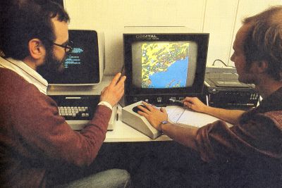
The IAS arrived and was installed at SSC during Christmas 1978. One of our engineers, Sonny Lundin, had done the acceptance testing in Vancouver, and had returned with a notebook crammed with notes from the brief course he had taken there. Still, when we fired up our new "toy" during the Christmas holiday, we were all novices. We quickly became fascinated with the possibilities. We had a lot of magnetic tapes containing Landsat imagery of Sweden, and it was a revelation to see what "no man had seen before" (with the exception of a few images on film): what our country looked like from 900 km altitude. There was a package of programs (SPIEL) that enabled us to manipulate images in real time, and there was a maximum-likelihood classifier. Above all, there was a package of geometrical correction programs that made it possible to correlate Landsat images with each other, and with maps, to a high degree of accuracy. - It is possible to just "stretch" digital images to fit a map, but to achieve good quality it is essential to model the geometry of the instrument, the spacecraft, and the Earth, and this is what the software did. - One of the key features was a routine that made it possible to find the corresponding points in two images of the same scene automatically - undoubtedly a spinoff from military work (cruise missiles). However, the geometrical correction package contained a lot of "spaghetti code" and seemed to have been assembled in a rush. - There were two 67 MB disk drives, one of which was mostly filled with the system, while the other one could be used to store image data. (A whole Landsat MSS scene was 40 MB.) With access to the source code, the next challenge became to modify some functions. Modern tools were absent, there was a line editor (QED) for editing the Fortran code, and the executable code was produced in two separate runs: compilation and linking, which took several minutes even for simple tasks. - I still remember the thrill when I made my first modification: changing a flag so that the image on the screen would be visible as it was being loaded. Our mission in remote sensing was to develop, explain
and promote its potential to the prospective user community. During
the following months and years we had a constant stream of scientists
and application experts visiting and doing work on the IAS. We also
had a considerable number of VIP visitors from the Nordic countries,
usually associated with the Nordic communications satellite project
(Nordsat, which later turned into Tele-X). Often we
just "happened" to have an image of their native town
on the screen for their visit.
My duties at SSC did not allow me to spend much time on the IAS during working hours. However, during the evening hours I was especially active in getting the geometrical precision correction package to perform at its full potential. When a British customer of Landsat tapes from our Kiruna station discovered that a correction introduced there to compensate for the non-linearity in the motion of a mirror in the MSS instrument onboard the satellite was applied incorrectly, I headed a hastily assembled "tiger team" to diagnose and correct the problem. This led to a calibration effort using hundreds of "ground control points" in the form of small islands in the Swedish-Finnish archipelago. Unfortunately, Sweden and Finland used different projections and geoid models for their maps, so there was a lot of work to be done to stitch the maps together.
The end result was that we came up with mirror correction curves so accurate that geometrical errors were reduced to less than half a pixel as measured with ground control points from maps, and to just a quarter of a pixel image-to-image. This was quite important in such applications as mapping forest clear-cuts that had occurred between two Landsat image acquisitions. All of this was heady stuff. More than once I returned to work late in the evening to evaluate the result of a computer run, or to start a new process that would run during the night. During weekends I was glued to the IAS. - We really considered ourselves the world champions in providing geometrically accurate Landsat images. Unfortunately, digital data from other sources than "our" satellite data were almost non-existent, and the real potential in satellite imagery could therefore not be fully realized during the 1980s. On one occasion we got our hands on a tape from a NOAA Tiros weather satellite. There was no format description and we did not even know that there were five spectral channels with interleaved data. On a modern PC, once we had read the data into the computer, it would be a matter of maybe 15 or 30 minutes to examine the data, unscramble it and turn it into an image, but with the turnaround time we were working under, we worked late into the night until we finally had a recognizable image on the screen: the Nile delta "upside down"! - On another occasion we received a tape from a planning authority in Stockholm. It contained thematic data that they wanted to be able to visualize on the computer screen. At half past nine, I reminded my colleague that the nearest hamburger bar would close at ten o'clock. Never mind, he said, we will be going home shortly. - I drove him home at four o'clock in the morning, mission accomplished. It was a beautiful summer morning. Under the pressure of other duties, the IAS became my "sea of tranquility". Late in 1979, when I served as the executive secretary of a government commission on the future of the Swedish aerospace industry, I felt that the whole world was resting on my shoulders. (My chairman Tony Hagström used to call me on the telephone: "I hope your pencil is glowing red [from writing our final report]".) Yet, I devoted an entire weekend to developing a routine on the IAS to rotate an image by an arbitrary angle. (This was mathematically trivial; the challenge was to manage the limited buffers available so as to optimize performance. A cubic convolution resampling of a whole satellite image would take hours - and the Interdata 8/32 was fast!) |